History
Local flora and fauna
The traditional custodians of this land are the Tommeginer tribe of Table Cape. They were one of the eight tribes that made up the north west linguistic group of Aborigines, a loose knit, social and economic confederation of maritime tribes that occupied a coastal strip extending from Table Cape to Cape Grim, and then down the West Coast to just north of the Macquarie Harbour.
The way they interpreted this land, used it, and respected its intrinsic values adds a layer of history that is a fascinating foundation to the story of this place. This foundation is not lost but understanding it is difficult for many of us, who are unfamiliar with the lore and culture of the first peoples. A little more of the indigenous history of this region can be found on the Waratah-Wynyard Council’s website here.
We hope to add to this and shed a little more detail on this history on these pages and are in the process of respectfully gathering these insights. We will share them when we can.
In relation to the areas European History, the Wynyard Historical Society was kind enough to share the following insights:
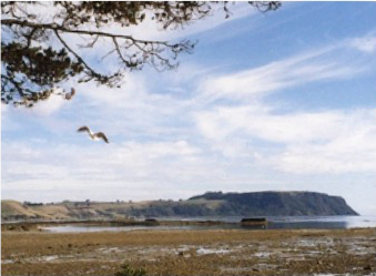
Port Creek was originally called Stinking Creek, probably because of the smell of rotting seaweed left behind at low tide. The name was officially changed in 1959.
Opposite Port Creek can be seen the last remains of a “new harbour” built in 1895. The Table Cape Marine Board was established in 1867, and a port developed on the Inglis River. By the late 1880s, silting at the river mouth made it difficult for larger steamships, which were replacing the small ketches and schooners, to access the river port.
The new harbour, about a mile to the east of the river mouth, designed by William Reid Bell, was completed in 1895.
It was soon found to be impractical in rough weather and was abandoned by 1901, and the wharf was removed in 1906. A small portion of the breakwater can still be seen.
Local shops and services
Heading towards Table Cape (west) this Pause Place is about a six minute walk to the Rotary Play Ground on the foreshore and nearby Café. From here its 12 minutes to our outdoor market held on the first and third Sunday of every month from 8 am to 2 pm along the East Wynyard foreshore.
A further 10 minutes will take you to the riverside boardwalk with its wharf, nearby Guttridge Gardens and views across the river. From there it’s a short walk to the centre of Wynyard with its shops and cafes.
If you head away from Table Cape (east) a 15 minute walk will take you to another Pause Place and a café. Beyond that is the beautiful and dramatic Doctors Rock, 50 minutes from here.
Too far to walk?
There is a bus stop just 5 minutes away at 32-46 Old Bass Highway. Click here for bus times